COORDINATE 0°: THE CENTER OF PEACE
The project defines peace not merely as an ideal, but as a spatial coordinate, a universal concept, and a common goal of humanity. The design aims to create a central point representing peace on a global scale; just as Greenwich established a reference point for time and space, “Coordinate 0” establishes a universal reference point for peace. The monument is shaped through the maps and borders that humanity has created to make sense of the world. Originally whole and natural, the earth has gradually been divided into lines that define nations, states, and identities. These borders represent not only physical separations but also political, cultural, and diplomatic identities. The project is designed to make visible the transience of these borders and their artificiality in contrast to the integrity of nature.
Cartography is the art of representing the earth’s surface through scientific, aesthetic, and technical means. It records not only geographical forms but also borders, identities, relationships, and the spatial memory of human history. A map presents the world not as a mere physical reality, but as a way for the human mind to comprehend and interpret it. Thus, cartography both represents nature and provides the ground for cultural, political, and ideological readings. This project employs cartography as a tool to conceptualize the earth’s divided state, both natural and human-made. The gridded ground is the foundation of this representation: an abstract network in which all geographical, political, and cultural relations of the world are systematized by human hands. The world map is placed upon this grid, preserving the physical realities of land and water masses; however, the borderlines are not directly emphasized. In this way, while pointing to the artificial divisions drawn by nations and diplomacy, the project also reveals their transience and fragility in the face of nature. Through this interpretation of cartography, the spatial order designed here becomes a representation of humanity’s ideals of peace and coexistence.
The gridded ground is chosen to make space measurable and legible. It represents the structural order created by humans in contrast to the natural irregularity of the earth. Each square holds a relationship, each line a border. The grid, as the carrier of space, forms the basic framework of the project. Continents and water masses are placed upon this order, highlighting the tension between natural structures and human-made boundaries. The ground establishes the foundations for movement, interaction, and dwelling. It is not merely a geometric order, but also a spatial representation of borders, separations, and unions. Designed upon the grid, the project revives the traces of human history at the intersection of space and time.
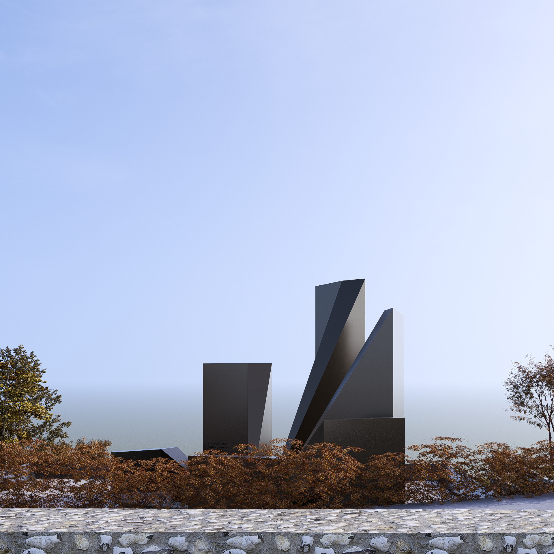
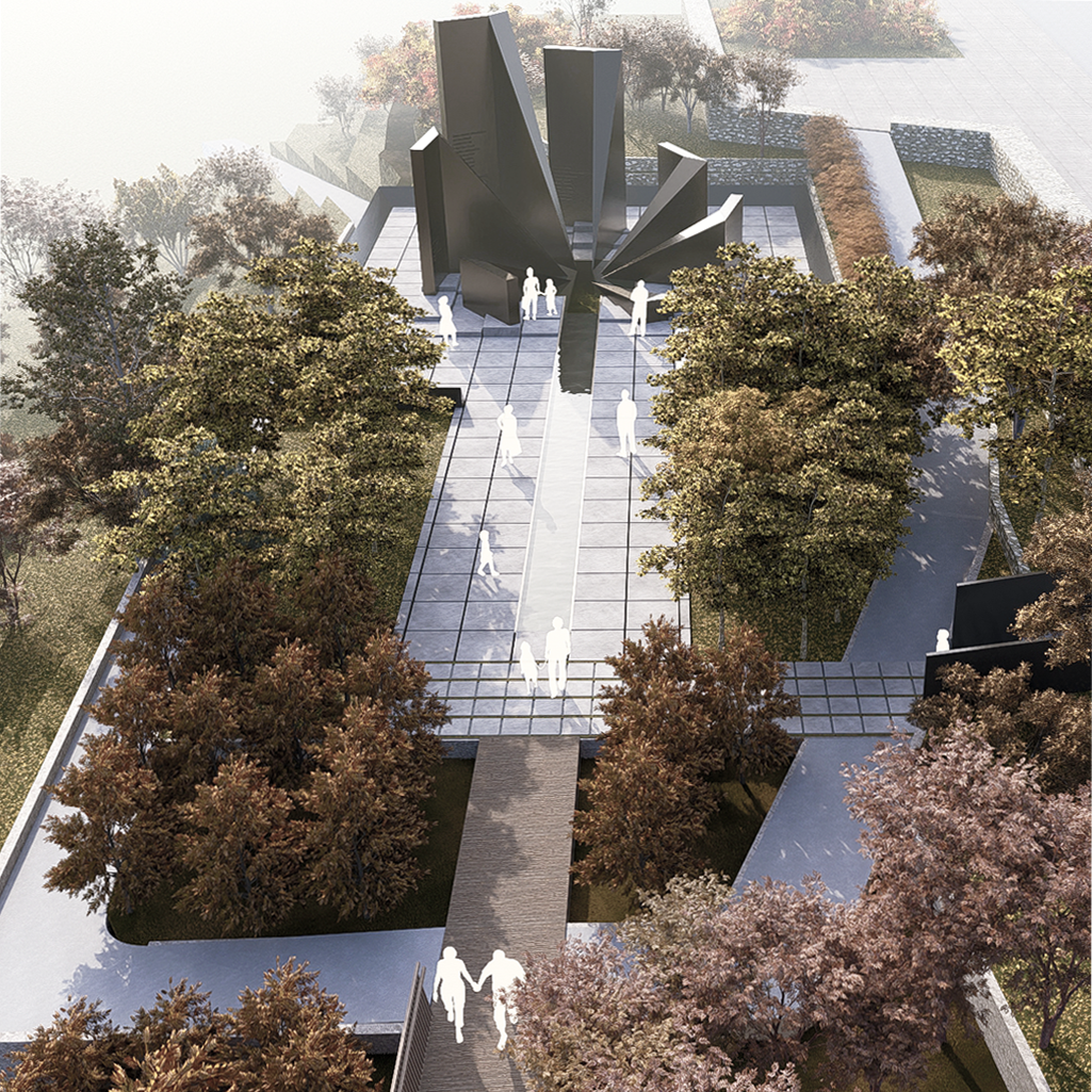
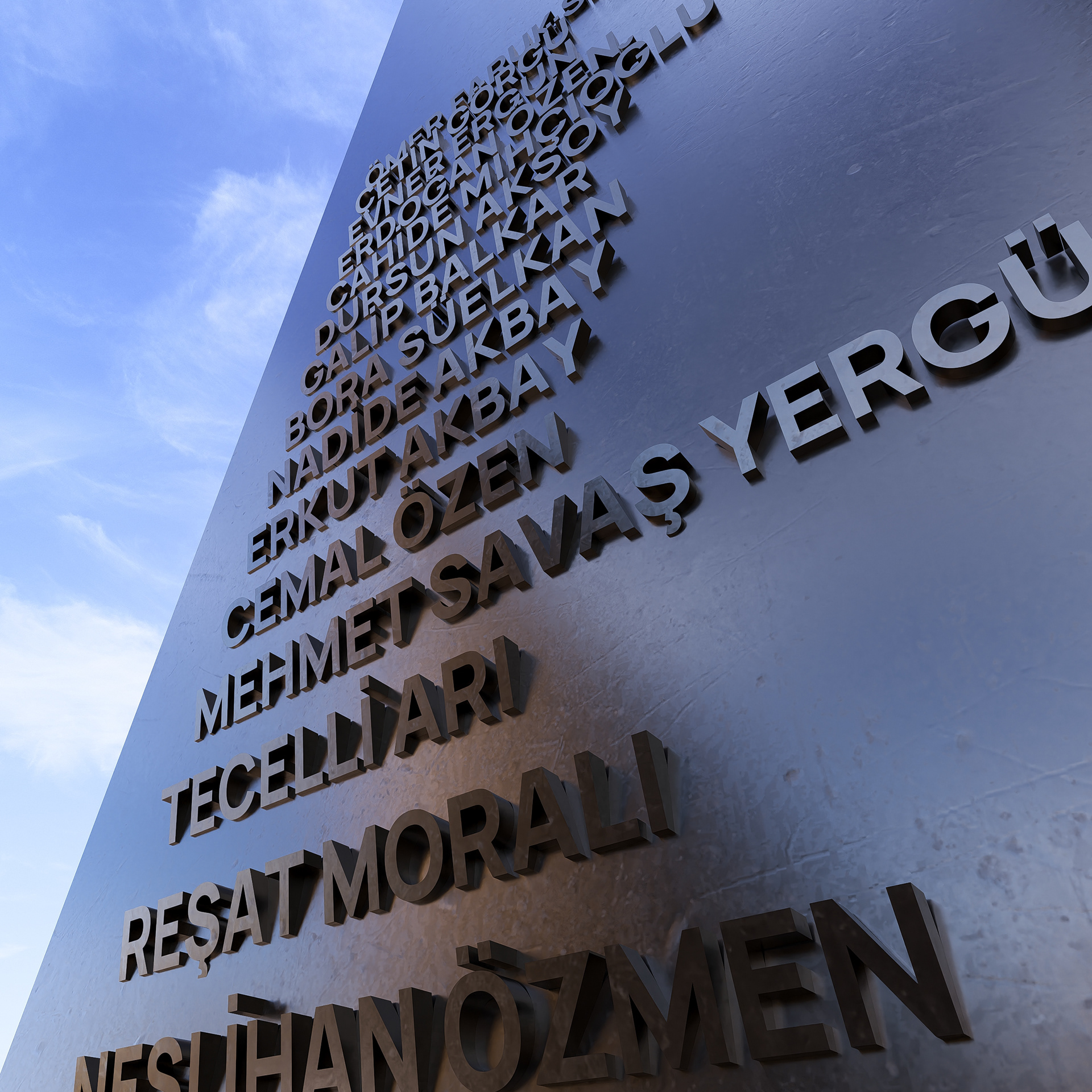
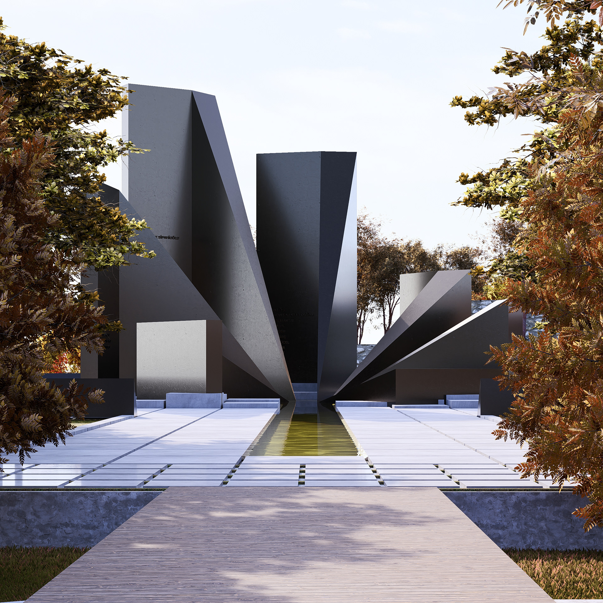
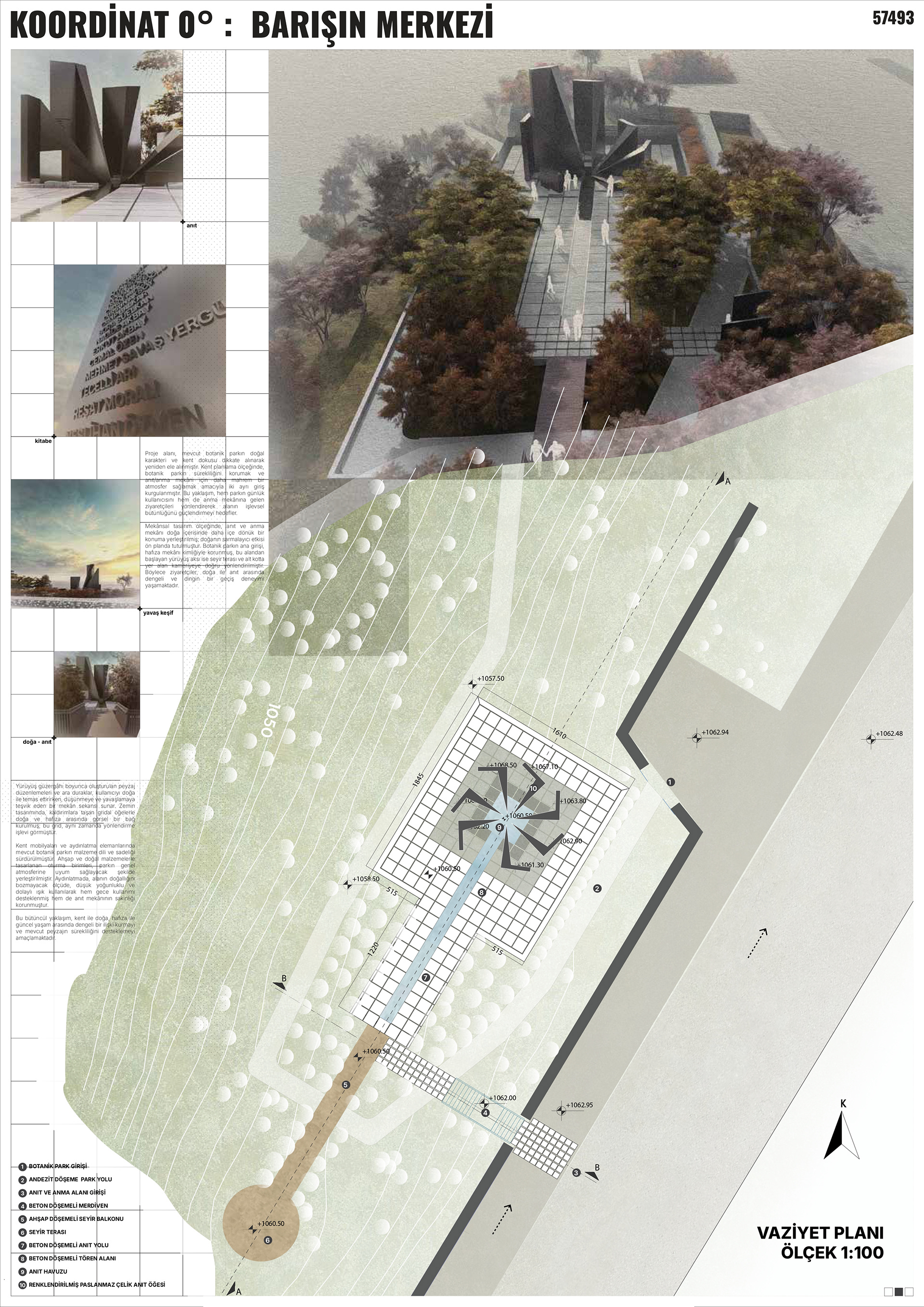
The monument site is laid out on a gridded ground encompassing the whole world. This order, at times interrupted or overlapping, emphasizes the ideological and temporary nature of maps and borders. The seven continents are represented by seven metal slabs rising in proportion to the number of diplomats martyred on each continent. These slabs stand as silent witnesses to both lost lives and unfinished missions. The difference in height reveals the scale of loss, while all continents, though carrying different weights, symbolize a shared will oriented toward peace. The slabs gain meaning not only through their form but also through the names inscribed on them. On each slab are written the names of the diplomats who lost their lives on that continent. Thus, individual sacrifices are remembered without anonymity; each life is honored, and the cost of peace is made visible.
The Coordinate 0 point is defined as the central reference for a global understanding of peace, equally distant from all continents. Radiating from this point, the axes are designed as lines reaching out to each continent, forming paths toward peace. These axes symbolize the relationships between the central point and the continents. Each axis reflects the contribution of the continents to peace and a shared understanding of humanity. This arrangement represents a quest for equality and unity that transcends borders.
Within the grid, a water element flowing toward the center forms both the conceptual and physical lifeline of the project. Water symbolizes the source of life, the natural connections between continents, and the continuity of peace. Flowing toward the center, water directs the visitor on a physical journey that becomes a conceptual call: reaching peace requires a constant flow and effort. Shadows cast by the slabs and the shifting light throughout the day and seasons change the atmosphere of the space, evoking memory not as fixed, but as living and transformative. This makes visible the idea that peace is a process to be rebuilt every day.
The artistic language of the monument emphasizes that borders can divide not only lands but also human minds—yet they can also open pathways toward peace. The fragmented grid reveals the geographic reflections of political conflicts and losses. The fluid grid implies the changeability of national identities and diplomatic missions over time. The double-layered grid demonstrates historical continuity and the mutable nature of borders through overlapping layers of maps. These interpretations invite the visitor to reflect upon the ideological nature of borders and the universal responsibility of peace.
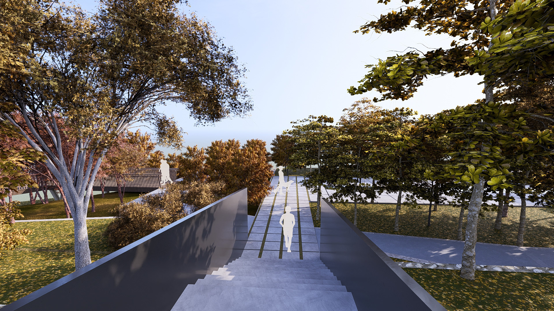
At the time Ankara was declared the capital of the Republic of Turkey, it was still a small town. The vineyards, gardens, and farmlands surrounding the city created a natural green belt. This belt defined the city’s physical boundaries and shaped a traditional garden-city character. Respecting this natural heritage, the monument is located within the Botanical Park, carefully integrated into the existing contours. In this way, it functions both as a “memorial balcony” facing the city and as a “pathway” opening into nature. As the visitor moves along the grid surface, they experience a constant transition and tension between nature and the monument.
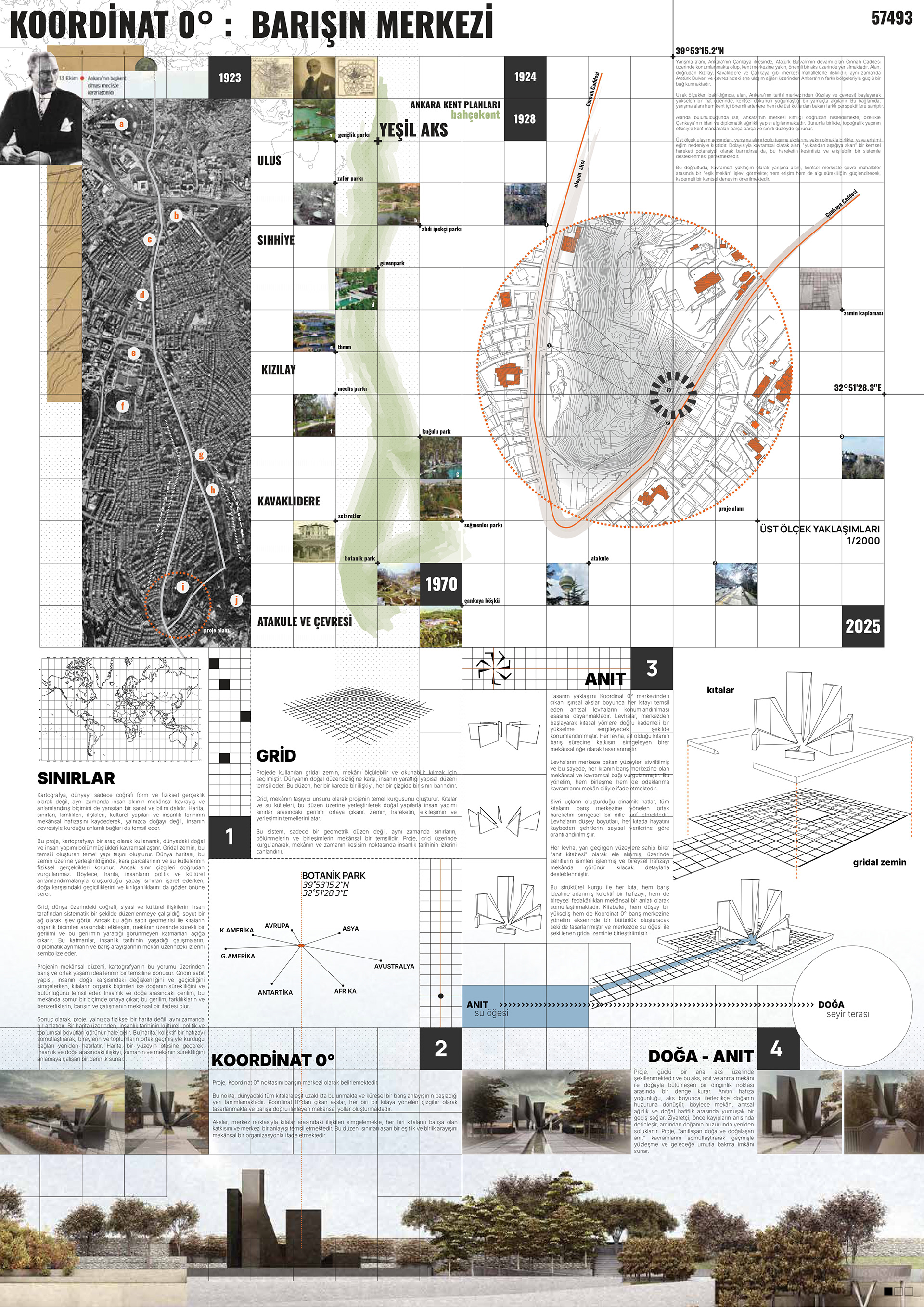
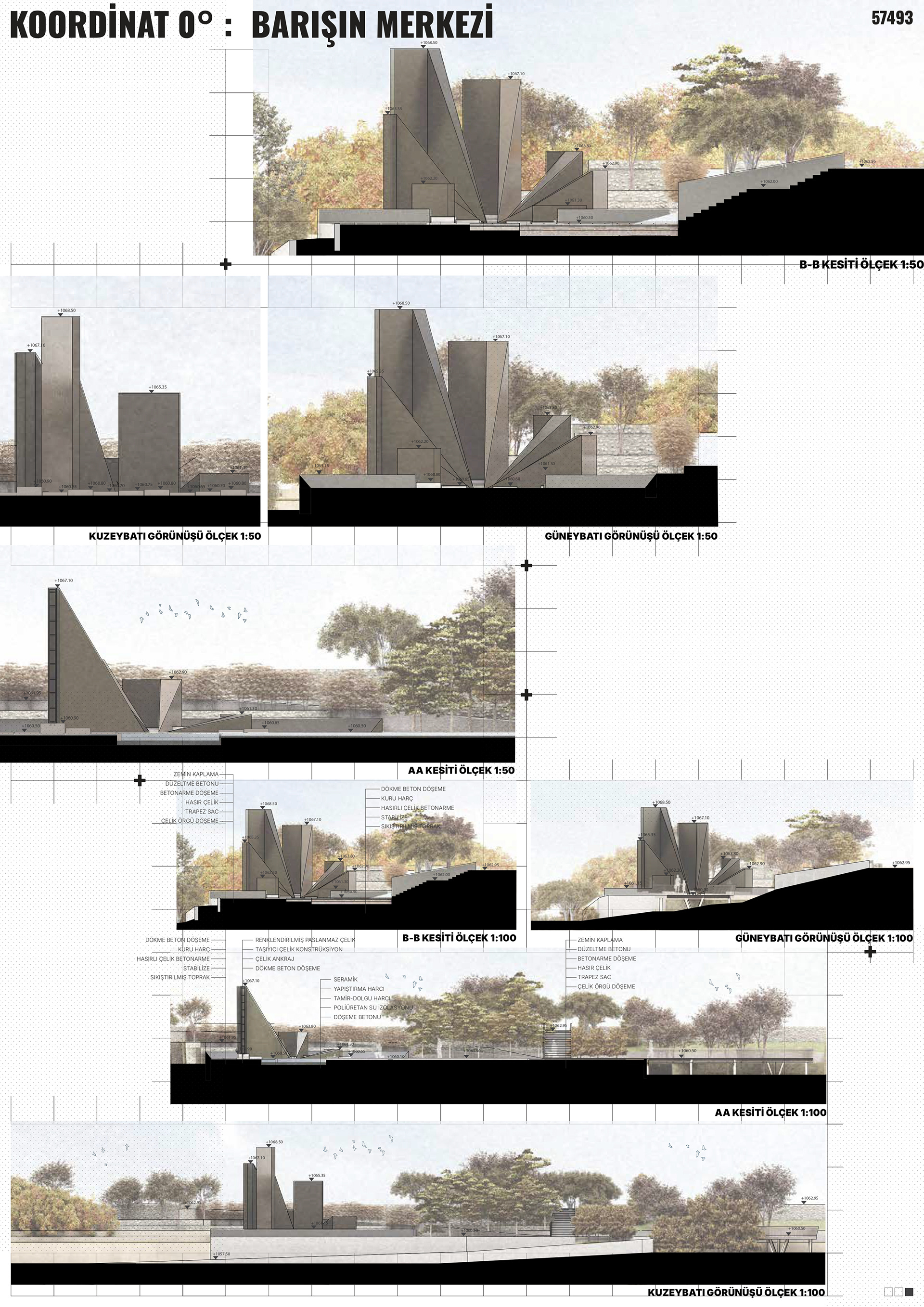
The selected materials are surfaces that change and age with time. The metal slabs develop a patina, symbolizing the interweaving of loss and remembrance over time. The concrete grid ground offers a static order, while the shadows of the slabs reveal the transience of the moment. The transformation of material and light reminds us that memory is a living process.
The pathway leading to the monument is lined with almond trees whose seasonal changes create different atmospheres throughout the year, offering visitors a sense of calm, remembrance, and focus on the monument. The dynamic form of the monument provides shifting perspectives as one approaches, establishing an interaction between landscape and monument that evolves with time and distance. The height of each slab, designed to represent its respective continent, corresponds to the number of diplomats martyred there. These slabs take the form of steles, each inscribed with names and complemented by openings symbolizing the lives lived. The steles, as reminders carrying the memory of the fallen, elevate each slab and link the central peace point with their sacrifice. Thus, each continent is embodied as a history dedicated to peace and a path traced by the diplomats who gave their lives.
“Coordinate 0: The Center of Peace” commemorates the losses of the past while making a strong call for the future of peace. It conveys, through space, the role of borders in human history, the place of loss in universal memory, and the need for peace to be continuously rebuilt. Voices rising from every continent converge at a single center, redrawing the geography of peace as a new map for humanity. This monument, while honoring those who lost their lives in the pursuit of diplomacy, emerges as a hopeful manifesto of peace—between the serenity of nature and the traces left by humanity.